3D Digitization in the Museum – Part 1: Photogrammetry

Rachael Cristine Woody
For example, in 2014 the Smithsonian Institution moved from experimentation to investment with the creation of the Smithsonian’s Digitization Program Office. In its first year the office was tasked with digitizing 10% of the Smithsonian’s 137 million objects—an endeavor which will likely take a decade, if not longer.
Two 3D Digitization Leaders
For museums new to 3D digitization, it’s worth exploring what tools are available before committing to a specific method. Of the several 3D digitization options that have been explored in the last two decades, two have emerged as leaders in the museum and cultural heritage fields: Photogrammetry and LIDAR scanning. Both options are achievable in a museum setting once equipment costs, setup, and software are evaluated to determine the best fit for the museum.
Photogrammetry
Photogrammetry is a method that mimics human sight and depth perception. Multiple photographs are taken of an object or structure and data points are generated from the information the photographs capture. These infer depth measurements and produce an authentic texturing effect of the subject photographed. In order to 3D capture an object with photogrammetry, an image must be taken on at least three different elevation levels in a 360 rotation with a photograph taken on at least every 20 mark. It’s important to be methodical in taking the pictures for photogrammetry as different angles, cameras, and lighting can all complicate the process of creating a 3D image. When completed, this method will yield a minimum of 90 images that can be synthesized to create a point cloud of the 3D object, and be further refined to reveal a very close to accurate, 3D digital representation.
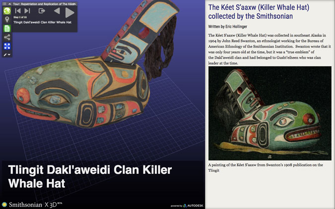
Photogrammetry example of an object:
The Kéet S’aaxw (Killer Whale Hat) collected by the Smithsonian.
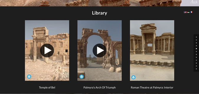
If photogrammetry is being conducted on a large environment or structure, a slightly different method is used. If the structure can be easily photographed by humans, then the photographer starts at the top end of the area being captured and slowly works their way to the opposite side. When the row has been captured, the photographer shifts down to capture the next row of images, making sure to overlap enough with the top row that the software can identify where the images overlap. If a large expanse such as a whole environment is being captured, the use of drones is employed. As the drones fly over an area, they take a photograph every second in an attempt to capture overlaying images of the environment. Methodical picture-taking in a systematic fashion, with little to no variation in setting or technology, is very important—multiple attempts might be made when performing photogrammetry on a large structure or environment.
Photogrammetry example of a large structure and environment:Palmyra’s Temple of Bel, Arch of Triumph, and Roman Theatre provided by the Arc/k Project.
Benefits of photogrammetry:
- Photographs used for photogrammetry can be taken by anyone with an entry-level knowledge of the process.
- Camera technology has advanced far enough that even cellphones can be used to generate a 3D digital reproduction.
- The processing of images for photogrammetry can be done with any photogrammetry software. This is not a method that requires a specific software system, or additional technical knowledge.
- Photogrammetry can be employed in any setting, and can accommodate small objects to vast environments.
Drawbacks of photogrammetry:
- At least a small amount of training or knowledge is needed in order to photograph the object or structure in a way that can be accurately rendered into a 3D digital model.
- Any error in the photograph capturing process can result in an error when trying to create a 3D digital model.
- Software is needed to stitch together the images. There are several options available, from free to $3500/year. Cultural Heritage Imaging recommends Agisoft PhotoScan with licenses that range from $179 – $3,499.
For more information on photogrammetry, please visit the Cultural Heritage Imaging’s website: culturalheritageimaging.org.
Next week is Part 2 in the two-part series “3D Digitization in the Museum”. Part 2 will investigate LIDAR scanning and provide recommendations for choosing a 3D digitization method.

Rachael Cristine Woody
Similar Posts
Museum Collections Online with Accessibility Principle 2: Operable
Compliance with WCAG Version 2.1 Principle 2: Operable
Museum Collections Online with Accessibility Principle 1: Perceivable
Compliance with WCAG Version 2.1 Principle 1: Perceivable, affecting information published from museum CMS to an online portal; expert guidance
Accessibility Standards for Museum Collections Online
A museum’s compliance with the ADA Title II 2024 update has benefits for its online content and for the museum’s community of users.
Museum TrendsWatch 2024: Digital Twins and Doom Loops & Combatting the Loneliness Crisis
Digital Twins is the construction of a digital surrogate for a person, place, or thing—one of several new concepts and trends in the museum sector.
